Close
Back


From now on you can download videos from our website
If you would also like to subscribe to the newsletter and receive our latest updates, click on the button below.
Enter the email address you registered with and we will send you a code to reset your password.
The password must be at least 12 characters long, no spaces, include upper/lowercase letters, numbers and symbols.
Click the button to return to the page you were on and log in with your new password.
08 July 2009
1 MIN READ
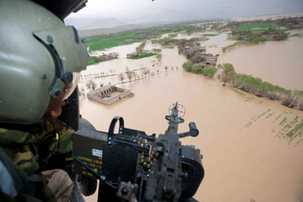
NATO’s Geo experts have created a map that predicts likely flooding areas in Afghanistan, making it possible to plan preventive action for future flood seasons. The map is soon to be formally handed over to the Afghan authorities in Kabul.
Afghanistan has always been a country with the periodic threat of flooding due to intense rainfall, the melting of snow or a combination of both phenomena. Every year, there are many fatalities and thousands of homes are destroyed as a result of these floods.
Using innovative technologies based on highly accurate 3D models and flood observations, the NATO Consultation, Command and Control Agency (NC3A) Geo Team have created the Afghanistan Flood Hazard Map (AFG-FHM) to predict where floods are likely to occur and to visualise its potential extent.
The map has been independently validated by renowned scientists, and has been described as extremely useful in predicting and preparing for future flooding. Due to the accuracy of the results it is possible to avoid constructing buildings in hazard zones or implement mitigations measures to protect infrastructure, thus saving millions of dollars in investments. The map can even help landmine clearing agencies prioritise their efforts thus preventing landmine migration.
The map will be released to the Afghan national authorities shortly, which will assist in minimising disasters like those of the past, as well as help to prepare and plan for relief operations.
Once the Afghanistan Flood Hazard has been released, more information and the map itself can be downloaded from the Afghanistan/ISAF section at http://www.cimicweb.org/.
For press enquiries, please contact Emilie Couture: Emilie.Couture@nc3a.nato.int
For technical inquires about the AFG-FHM please write to: floodmap@nc3a.nato.int